1. About
BeachLISA (Beach Litter Image Segmentation Analysis) is an advanced solution developed by the Japan Agency for Marine-Earth Science and Technology (JAMSTEC) that utilizes AI technology to automatically detect beach litter in images. In addition to detecting marine debris in beach photographs taken from the ground, it can analyze drone aerial imagery to estimate the distribution and coverage area of beach litter. This system was developed to support research on marine pollution caused by plastic waste and to assist local governments in implementing efficient debris collection operations. Compatible with Chrome and Edge browsers, users can obtain analysis results simply by uploading images.
Please note that analysis may take some time, so please wait for the results to be displayed.
2. How to Use
- 1. Upload Images: Upload beach images (including aerial photos) through drag and drop. Multiple images can be analyzed simultaneously
- 2. Run the analysis: After uploading, the system will automatically start the AI analysis. After the calculation is complete, the results will be displayed.
- 3. Download the results: You can download the results in bulk using the download button.
Detection Area Colors
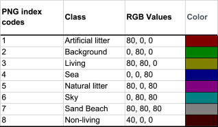
RGB Values are in hexadecimal. For detailed class information, please refer to the following paper:
The BeachLitter dataset for image segmentation of beach litter
https://doi.org/10.1016/j.dib.2022.108072
High Resolution
This is an option that automatically divides large images and uses the SAHI method for high-accuracy segmentation estimation. Please ensure this option is turned on when estimating drone aerial images. Processing time is approximately 2 minutes. Split and merge settings can be modified in the detailed options.
GSD
This is a specialized feature for analyzing orthophotos of beaches taken by drones. You can set the Ground Sampling Distance (GSD). By setting the GSD, you can obtain the coverage area (cm2) of detected regions.
Processing Time Guidelines
Analysis takes approximately 40 seconds per image, and about 2 minutes for larger images that require split estimation. Multiple images can be processed in batch. In this case, parallel processing allows for faster completion than processing one image at a time.
3. Disclaimer
While this system strives to support the detection of beach litter, please note the following points:
- Regarding Completeness: Although this system uses advanced AI technology, we cannot guarantee complete detection accuracy. Detection may be difficult depending on the type and condition of beach litter. False detections and oversights may occur.
- Regarding Data Handling: Uploaded images and analysis results may be used anonymously for system improvement.
- Limitation of Liability: We assume no responsibility for any direct or indirect damages incurred by users through the use of this system.
- Terms of Use: This system is available for non-commercial use only free of charge. For commercial use, please contact here.
4. Citation
When publishing research results using this system, please cite the following papers:
- * Hidaka, M., Matsuoka, D., Sugiyama, D., Murakami, K., & Kako, S. (2022). Pixel-level image classification for detecting beach litter using a deep learning approach. Marine pollution bulletin, 175, 113371.
- * Sugiyama, D., Hidaka, M., Matsuoka, D., Murakami, K., & Kako, S. (2022). The BeachLitter dataset for image segmentation of beach litter. Data in Brief, 42, 108072.
5. Development Team

Japan Agency for Marine-Earth Science and Technology (JAMSTEC)
Daisuke Sugiyama
Japan Agency for Marine-Earth Science and Technology (JAMSTEC)
So Hirawata

Kagoshima University Graduate School of Science and Engineering
Japan Agency for Marine-Earth Science and Technology (JAMSTEC)
Shinichiro Kako

Kagoshima University Graduate School of Science and Engineering
Japan Agency for Marine-Earth Science and Technology (JAMSTEC)
Mitsuko Hidaka

Japan Agency for Marine-Earth Science and Technology (JAMSTEC)
Shintaro Kawahara

Japan Agency for Marine-Earth Science and Technology (JAMSTEC)
Koshiro Murakami

Japan Agency for Marine-Earth Science and Technology (JAMSTEC)
Daisuke Matsuoka
1. システムについて
BeachLISA (Beach Litter Image Segmentation Analysis)は、国立研究開発法人海洋研究開発機構が開発した、画像中の海岸漂着ごみを自動的に検出するためのAI技術を利用した先進的なシステムです。海岸を撮影した画像中の漂着ごみを検出するほか、ドローンによる空撮画像を分析し、海岸漂着ごみの分布状況や被覆面積を推定することも可能です。このシステムは、プラスチックごみなどによる海洋汚染の研究や、地方自治体等による効率的なごみ回収作業の実施を支援するために開発されました。ChromeおよびEdgeブラウザに対応しており、ユーザーは画像をアップロードするだけで分析結果を得ることができます。
分析には時間がかかる場合がありますので、結果が表示されるまでしばらくお待ちください。
2. 利用方法
- 1. 画像のアップロード : ドラッグアンドドロップで、分析したい海岸画像(空撮画像含)をアップロードします。なお、複数の画像を一度に分析することも可能です
- 2. 推定の実行 : アップロード後、システムが自動でAI分析を開始します。計算完了後、結果が表示されます。
- 3. 結果のダウンロード : ダウンロードボタンで結果が一括ダウンロード可能です。
検出領域の色について
RGB Valuesは16進数。クラスについての詳細は下記論文を参照:
The BeachLitter dataset for image segmentation of beach litter
https://doi.org/10.1016/j.dib.2022.108072
High Resolutionについて
サイズの大きな画像を自動で分割し、SAHIという手法で高精度に分割推定するオプションです。ドローンの空撮画像に対して推定を行う場合は必ずオンにしてください。処理時間は2分程度かかります。詳細オプションで分割結合の設定を変更できます。
GSD(cm)について
ドローンによって空撮された海岸のオルソ画像を分析する際の専用機能です。地上解像度(GSD: Ground Sampling Distance)を設定できます。GSDを設定することで、検出された領域の被覆面積(cm2)を得ることができます。
処理時間の目安
一枚の分析には約40秒、サイズの大きな画像の場合は分割して推定するために約2分かかります。複数の画像を一括で推定することもできます。この場合、一括で並列処理されるため、一枚ずつより高速に完了します。
3. 免責事項
当システムは、海岸漂着ごみの検出を支援するために最善を尽くしていますが、以下の点について留意をお願いします。
- 完全性について : 当システムは高度なAI技術を使用しておりますが、検出結果の完全性を保証するものではありません。漂着ごみの種類や状況によっては、検出が困難な場合があります。誤検出や見逃しが発生する可能性があります。
- データの取り扱いについて : アップロードされた画像や分析結果は、システムの改善のために匿名で使用されることがあります。
- 責任の制限 : 利用者が当システムの使用によって生じたいかなる直接的または間接的な損害について、一切の責任を負うものではありません。
- 商用利用について : 当システムは非商用目的に限り無償で利用できます。商用利用についてはこちらに相談してください。
4. 成果発表時の引用
本システムの利用結果を用いて研究成果を発表する場合は、以下の論文を引用してください:
- ・Hidaka, M., Matsuoka, D., Sugiyama, D., Murakami, K., & Kako, S. (2022). Pixel-level image classification for detecting beach litter using a deep learning approach. Marine pollution bulletin, 175, 113371.
- ・Sugiyama, D., Hidaka, M., Matsuoka, D., Murakami, K., & Kako, S. (2022). The BeachLitter dataset for image segmentation of beach litter. Data in Brief, 42, 108072.
5. 開発メンバー
国立研究開発法人海洋研究開発機構
杉山 大祐
国立研究開発法人海洋研究開発機構
平綿 素望
鹿児島大学大学院理工学研究科
国立研究開発法人海洋研究開発機構
加古 真一郎
鹿児島大学大学院理工学研究科
国立研究開発法人海洋研究開発機構
日髙 弥子
国立研究開発法人海洋研究開発機構
川原 慎太郎
国立研究開発法人海洋研究開発機構
村上 幸史郎
国立研究開発法人海洋研究開発機構
松岡 大祐